- SEARCHING FOR SUGAR LAND -
Ocupación: Final Thesis (ETSAM)
Programa: Landscape, urbanism and architecture
Localización: Detroit, MI, EEUU
Fecha: September 2016
Searching for Sugar Land is the result of an extensive and complex research that seeks alternatives to understand and intervene in the reality that Detroit is living today.
This city has been shrinking since the 1950s. This particular urban phenomenon has left a unique landscape composed by more than 105,000 empty lots, 50,000 abandoned houses and more than 30 square kilometers of underutilized land.
The main purpose of this project is to reorient Detroit's future by reconnecting the urban fabric and boosting the city's own identity through the interaction with its citizens. This project pretends to offer a global intervention in the territory according to the context of emergency and precariousness that suffers.
/// THE HIPERCITY
The city is living an important series of urban changes that are transforming the way we study and intervene on it. The new technologies are increasing our experience of the city as an amplification of our capacities to perceive and inhabit the physical and virtual environment.
The city should be connected to its citizens trough technology, making them part of the transformative process and decision making. This project understands architecture as part of a global purpose for the city. In order to understand the architectural intervention it is necessary to adopt a multiscalar vision of the city.
This new perspective allows us to analyze different pixels of the city that coexist at different scales. As a result, we obtain an hyper-connected network of Detroit that give us a transversal and simultaneous view of the interventions that are taking place in the whole territory.
/// MAPPING DETROIT
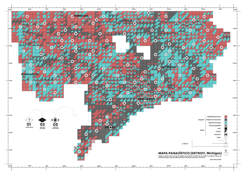
One of the first step of the project was to develop a map that shows the landscapes that will exist in the future of Detroit. In order to make this map it was necessary to collect all the cartographic information and digital mapping available on the internet so we could understand the real panorama of the current territory.
The final map is made by a matrix of 500x500 meters, based on the matrix of "the square mile" already used in other territorial mappings of America. Each of these "pixels" is classified according to three categories that determine the landscape that the “pixel” aspires to develop. (Habitability & Culture, Production & Innovation, Vegetation & Energy).
The purpose of this matrix is to obtain an accurate and flexible information about the landscape prevailing in each area. This cartographic system generates a new urban framework open and dynamic that bets on the diversity of uses and the recovery of the preexistence.
6 types of landscapes are defined for Detroit, these typologies approach the recovery of industrial zones, the reforestation of uninhabited areas or the improvement of consolidated neighborhoods among others.
Based on the division of districts made by the City Council in 2013, the project proposed the incorporation of a decentralized network for management, exchange and distribution of the resources of the city, in favor to the local needs of each neighborhood.
The city will become a collective place in continuous planning when the user takes part of the developing process.
/// YOU WILL BE THE KING OF YOUR “HOOD”
Our job as professional planners has been transformed, we must act as interlocutors between the inhabitants and the city. We must create the platforms for communication between agents and we must promote the local empowerment of users to take control, evaluate and develop their own space in the city.
Thanks to the advances in the field of technology it is possible to establish new communication channels. “Apps” will help us to evaluate the space surround us. The user will surf through a virtual network of the environment to connect with the physical space and other users.
/// ARCHITECTURE
The architectural proposal is marked by the inefficiency of finding a unique answer to solve the problem of the city. For this reason the "catalog" format is proposed as a flexible solution that allows activating different strategies of transformation and improvement of the urban space.
A progressive reactivation of the spaces in Detroit, according to the real needs of each neighborhood, will avoid that they become "ruins" and therefore, in obsoleted spaces, so we will give them a second chance to resurface.
Detroit’s future will finally find itself in the hands of the people who really inhabit and care about it. This city has the potential to become the referent to other cities in the world involved in similar processes of urban decline applying a sustainable and participatory urban model. The city of the future should be subjected to a flexible, transversal and dynamic planning, where its citizens will be connected with the urban space through a virtual platform of communication.


